


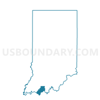
CLAY 02, Spencer County, Indiana
About
Outline

Summary
| Unique Area Identifier | 580626 |
| Name | CLAY 02 |
| County | Spencer County |
| State | Indiana |
| Area (square miles) | 2.68 |
| Land Area (square miles) | 2.36 |
| Water Area (square miles) | 0.32 |
| % of Land Area | 87.98 |
| % of Water Area | 12.02 |
| Latitude of the Internal Point | 38.10579580 |
| Longtitude of the Internal Point | -86.93187880 |
Maps


Graphs
Select a template below for downloading or customizing gragh for CLAY 02, Spencer County, Indiana


Neighbors
Neighoring Voting District (by Name) Neighboring Voting District on the Map
- CARTER 01, Spencer County, IN
- CARTER 04, Spencer County, IN
- CLAY 01, Spencer County, IN
- CLAY 03, Spencer County, IN
- HARRISON 02, Spencer County, IN
Top 10 Neighboring County Subdivision (by Population) Neighboring County Subdivision on the Map
- Carter township, Spencer County, IN (3,258)
- Clay township, Spencer County, IN (2,801)
- Harrison township, Spencer County, IN (2,000)